I am currently a Ph.D student at LIESMARS, Wuhan University, under the supervision of Prof. Bisheng Yang and Prof. Zhen Dong. Previously, I received the B.S. degree from the School of Earth Sciences and Engineering, Hohai University, in 2020.
My research focuses on 3D urban morphology, encompassing understanding, reconstruction, utilization of urban elements through multi-source remote sensing data.

Action required
Problem: The current root path of this site is "baseurl ("_config.yml.
Solution: Please set the
baseurl in _config.yml to "Education
-
 LIESMARS, Wuhan UniversityPh.D. in Photogrammetry and Remote SensingSep. 2023 - Now
 -
LIESMARS, Wuhan UniversityM.S.(Trans. to Ph.D.) in Photogrammetry and Remote SensingSep. 2020 - Jul. 2023
-
 SESE, Hohai UniversityB.S. in Surveying and Mapping Engineering (Rank 1/88)Sep. 2016 - Jul. 2020
Honors & Awards
-
Fundamental Project for PhD student from NSFC (¥300K)2025
-
Outstanding Student Presentation (Master's/PhD Candidates)" at the2nd China Conference on Spatial Information Technology2025
-
National Scholarship for Ph.D. (Top 3%)2024
-
First Prize Scholarship of Wuhan University (Top 5%)2024
-
Outstanding Graduate Student of Wuhan University (Top 10%)2024
-
Grand Prize in the 7th National LiDAR Data Processing Competition (1st)2023
-
National Scholarship for Undergraduates (Top 2%)2019
-
Jiangsu Province Longteng Scholarship (Top 1%)2019
-
CCCC Fourth Harbor Engineering Scholarship (Top 1%)2019
-
First Prize of the 3th Jiangsu University GIS Innovation Competition (1st)2018
-
Second Prize of the 9th National College Mathematics Competition (Top 5%)2018
-
Third Prize of the 14th Jiangsu University Mathematics Competition (Top 10%)2017
Selected Publications (view all )
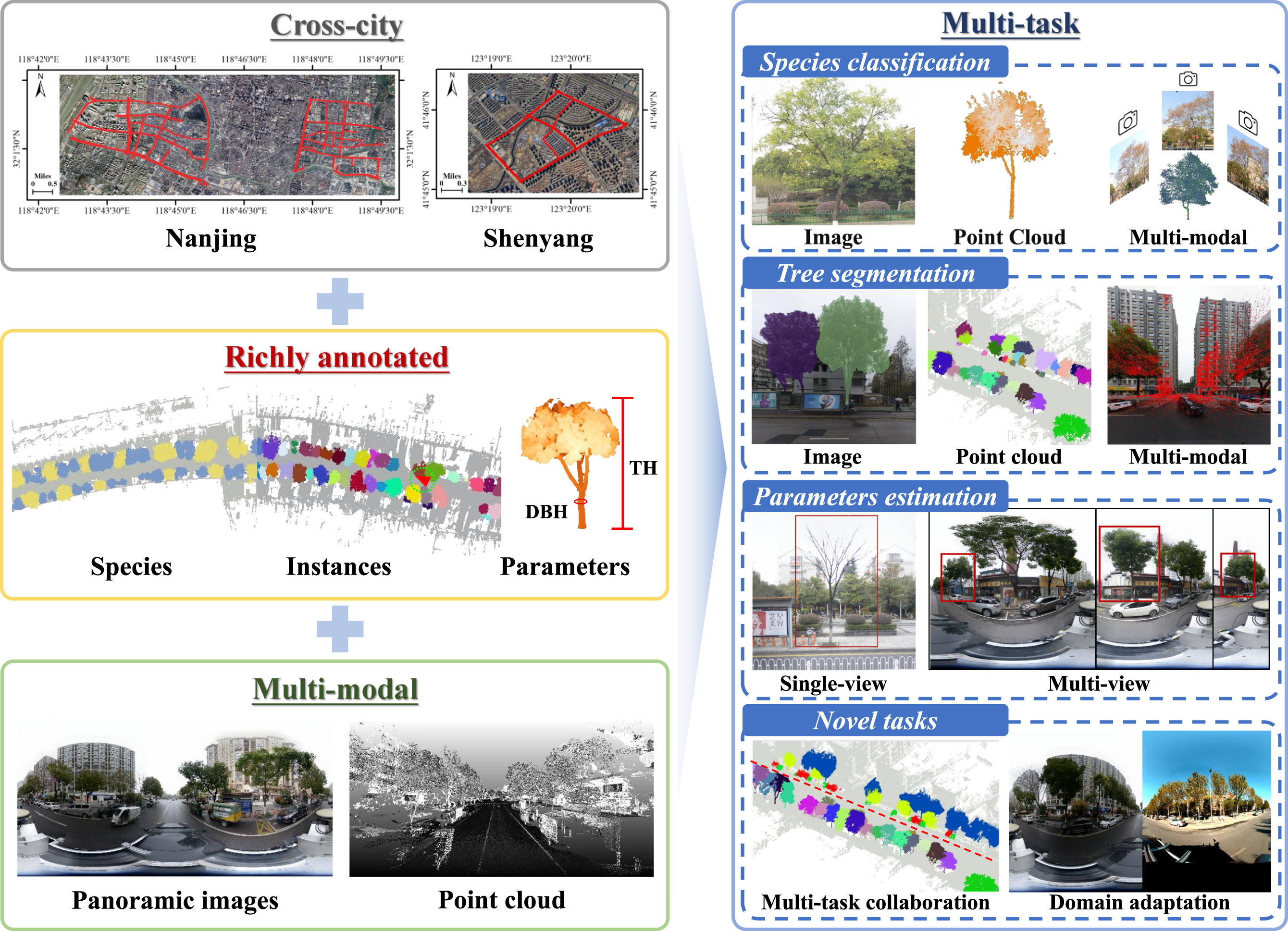
WHU-STree: A multi-modal benchmark dataset for street tree inventory
Ruifei Ding†, Zhe Chen†, Wen Fan, Chen Long, Huijuan Xiao, Yelu Zeng, Zhen Dong*, Bisheng Yang
ISPRS Journal of Photogrammetry and Remote Sensing (IF: 12.2) 2026
We introduce WHU-STree, a cross-city, richly annotated, and multi-modal urban street tree dataset designed for comprehensive inventory analysis, from initial individual tree segmentation, through species classification, to macro-level asset management. Besides, we implement several novel settings, making it possible to realize certain ideas that are difficult to achieve in traditional MMS datasets, such as concurrently supporting over 10 inventory tasks, integrating synchronized point clouds with high-resolution images, and benchmarking cross-domain multi-modal fusion challenges.
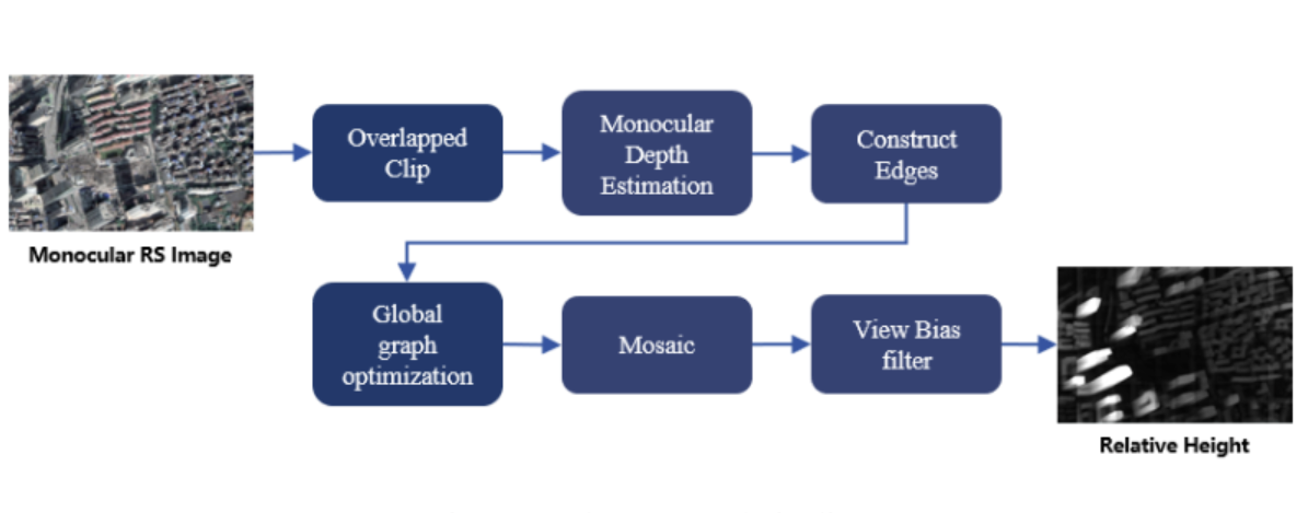
A training-free method for estimating the relative height of buildings
Zhe Chen, Chengjie Li, Fuxun Liang, Tong Peiling, Chen Long, Zhen Dong, Bisheng Yang*
The International Archives of the Photogrammetry Remote Sensing and Spatial Information Sciences 2025
We propose a training-free approach based on a vision foundation model that achieves highly accurate, annotation-free estimation of individual building heights by extracting and structurally optimizing relative depth from high-resolution remote sensing imagery, significantly outperforming existing baselines.
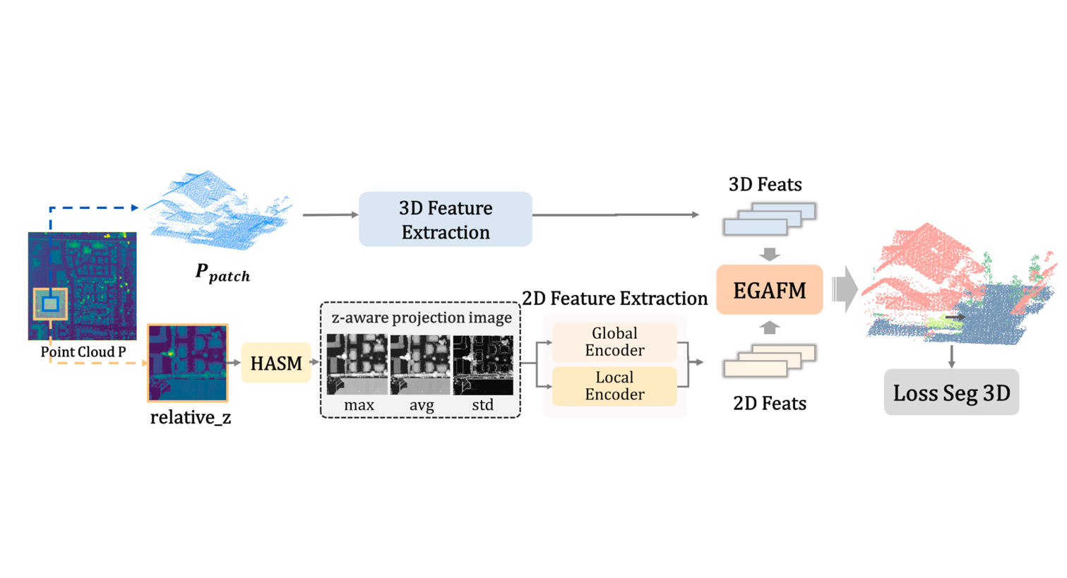
A novel projection map driven multimodal fusion framework for ALS point cloud semantic segmentation
Pangyin Li†, Zhe Chen†, Chen Long, Huazu Zhang, Yang Lv, Ronggang Huang, Zhen Dong, Bisheng Yang*
International Journal of Applied Earth Observation and Geoinformation (IF: 8.6) 2025
We introduce EGAFNet, a novel multimodal framework designed for ALS point cloud semantic segmentation, from the initial elevation-guided input representation, through dual-branch feature extraction, to adaptive 2D-3D feature fusion. Besides, we implement several novel settings, making it possible to realize certain ideas that are difficult to achieve in traditional multi-sensor fusion methods, such as utilizing single-source ALS data for multimodal perception, adaptively scaling object heights in 2D projections, and mitigating feature confusion caused by elevation occlusion.
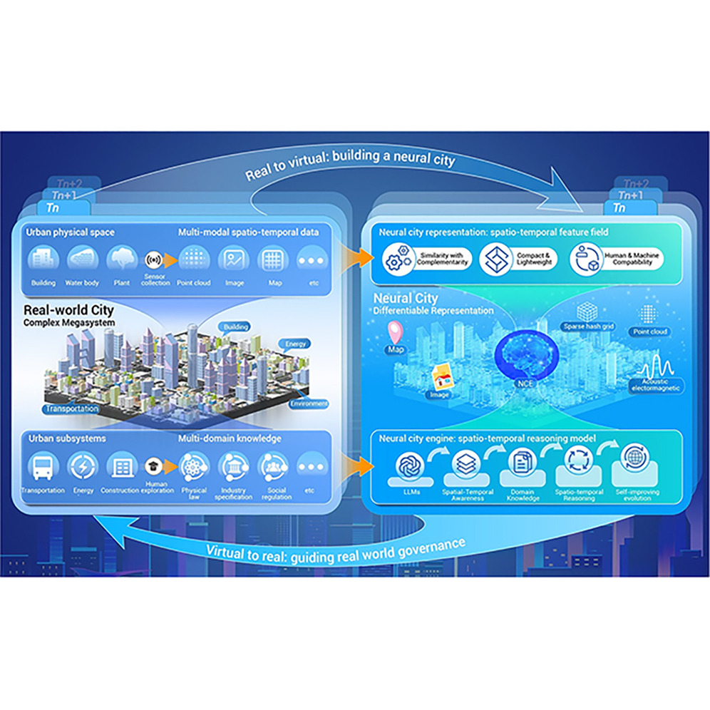
The Neural City: A next-generation spatio-temporal intelligence paradigm for urban holistic governance
Zhen Dong†, Haiping Wang†, Zhe Chen, Chen Long, Yuning Peng, Yuan Liu, Fuxun Liang, Jian Zhou, Yiping Chen, Fan Zhang, Bisheng Yang*, Deren Li
The Innovation (IF: 25.7) 2025
We outline Neural City to enable end-to-end urban governance, seamlessly linking raw urban data to holistic urban governance, achieving "6W+4R" governance.
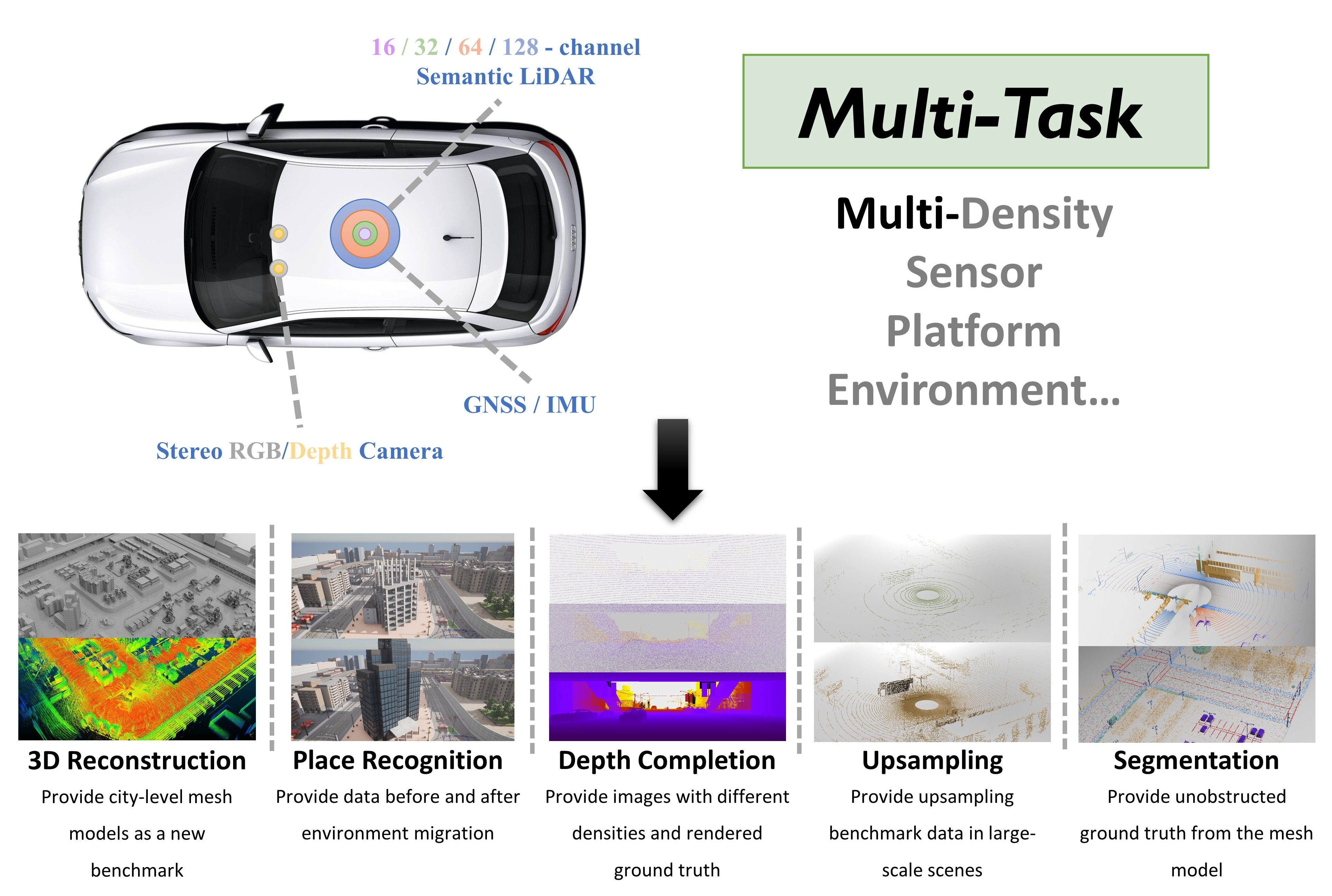
WHU-Synthetic: A Synthetic Perception Dataset for 3D Multi-task Model Research
Jiahao Zhou†, Chen Long†, Yue Xie, Jialiang Wang, Conglang Zhang, Boheng Li, Haiping Wang, Zhe Chen*, Zhen Dong
Transactions on Geoscience and Remote Sensing (IF: 8.6) 2025
We introduce WHU-Synthetic, a large-scale 3D synthetic perception dataset designed for multi-task learning, from the initial data augmentation, through scene understanding , to macro-level tasks. Besides, we implement several novel settings, making it possible to realize certain ideas that are difficult to achieve in real-world scenarios, such as sampling on city-level models, providing point clouds with different densities, and simulating temporal changes.
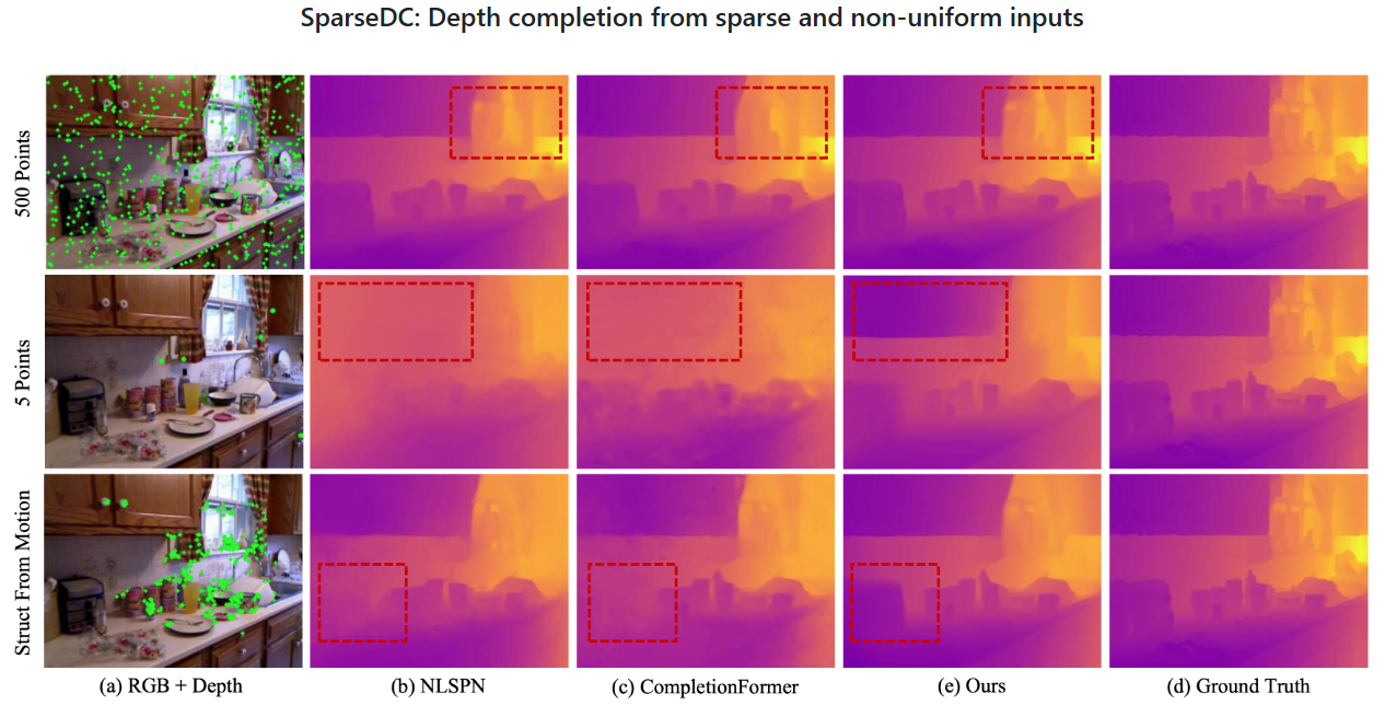
SparseDC: Depth Completion From Sparse and Non-uniform Inputs
Chen Long*, Wenxiao Zhang*, Zhe Chen, Haiping Wang, Yuan Liu, Zhen Cao, Zhen Dong†, Bisheng Yang
Information Fusion (IF: 14.8) 2024
SparseDC is a model for Depth Completion from Sparse and non-uniform inputs. Numerous experiments conducted both indoors and outdoors show how robust and effective the framework is when facing sparse and non-uniform input depths.
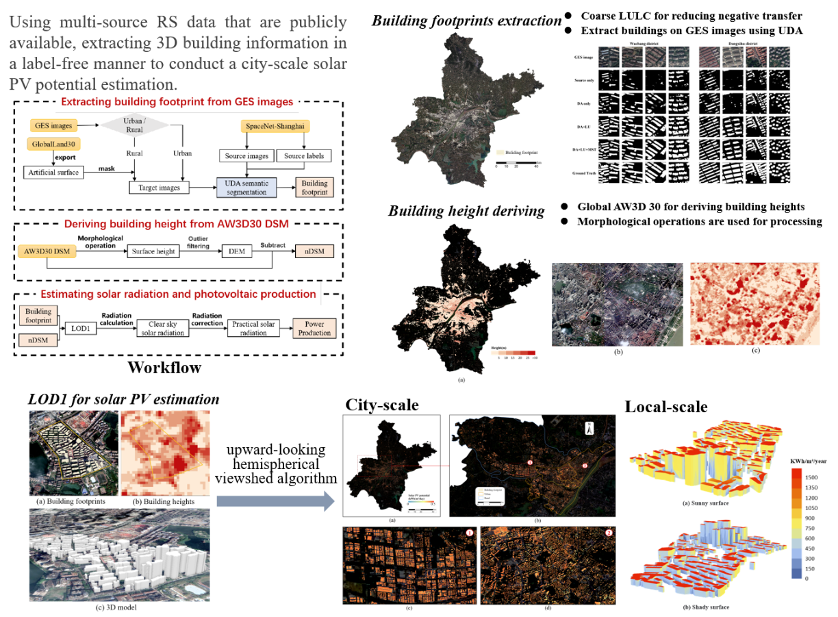
City-scale solar PV potential estimation on 3D buildings using multi-source RS data: A case study in Wuhan, China
Zhe Chen, Bisheng Yang†, Rui Zhu, Zhen Dong
Applied Energy (IF: 10.1) 2024
This study proposes a framework for estimating the solar PV potential of city-level building surfaces without human annotation and data acquisition costs. Buildings are extracted from Google satellite images through multi-space joint optimization domain adaptation network, and LoD1 models are generated by combining global DSM with building footprints. The framework was verified by taking Wuhan city as an example.
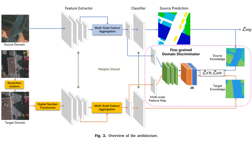
Joint alignment of the distribution in input and feature space for cross-domain aerial image semantic segmentation
Zhe Chen, Bisheng Yang, Ailong Ma, Mingjun Peng, Haiting Li, Tao Chen, Chi Chen†, Zhen Dong
International Journal of Applied Earth Observation and Geoinformation (IF: 7.6) 2022
A framework to jointly align the distribution in input and feature space for cross-domain aerial image semantic segmentation, our method demonstrates excellent performance in various cross-domain scenarios, including the discrepancy in geographic position and the discrepancy in both geographic position and imaging mode.
All publications
Selected Projects (view all )
Calculation of 3D Parameters of Roadside Trees Based on MLS Clouds
Guided by Prof. Bisheng Yang and Prof. Zhen Dong from Wuhan University.
2023.04 - 2023.10
Research group proposed a confidence-guided roadside tree extraction algorithm. Based on this algorithm, I further calculate the 3D parameters of roadside trees such as the crown volume, DBH and height, etc. The method has been integrated into Point2Model, a point cloud intelligent processing software.

Electric Grid Unmanned Crowd Intelligence Inspection System Report Software
Guided by Prof. Bisheng Yang, Prof. Zhen Dong and Prof. Chi Chen from Wuhan University.
2021.02 - 2021.08
As a core developer, I was mainly responsible for implementing functions such as project management, power line extraction, power line fitting, and point cloud coloring. The software has been scaled up in more than ten provinces and cities in China, generating significant social and economic benefits.